Case 01: AS+P
Rethinking urban planning
Smart technologies, liveable neighbourhoods, interdisciplinary cooperation – international planning office AS+P provides insights into modern urban design.
By 2040, 14 new high-rise buildings will shape the skyline of Frankfurt. The foundation for this is the High-Rise Development Plan, which will significantly transform the appearance of the financial metropolis. A milestone for both the city and planning office Albert Speer + Partner (AS+P), who developed the underlying concept framework. Friedbert Greif, Managing Partner at AS+P, explains: “When it comes to further developing Frankfurt’s inner city, it’s not just about defining new high-rise locations. It’s about creating urban and liveable neighbourhoods – and about the quality of public space.”
Friedbert Greif,
Managing Partner at AS+P

Jürgen Häpp,
Independent Advisory Partner at AS+P
For Greif and Jürgen Häpp, Independent Advisory Partner at AS+P, the first step in any urban planning process is to understand the site and its use. To achieve this, the experts rely on smart technologies – such as digital wind and solar simulations, which can be used to determine the impact of planning measures on the public space from early on. “For us as urban planners, a truly comprehensive use of sensors in urban areas would be extremely helpful in developing a deeper understanding: How and when do people use public spaces? How does a temporary road closure affect traffic flow? Which neighbourhoods need investment to make them more climate-resilient? Plenty can be done here already, but more data will always be valuable for planning. There is major potential here,” says Häpp.
Overall, the urban planner sees great opportunities in the use of urban technology: “In Germany, we are seeing only limited spatial growth in cities in favour of inner development. This means that over 90 per cent of the our future cities have already been built. We won’t be able to fundamentally change this urban mass, but urban technologies can help make cities fit for the future – provided they are used appropriately and beneficially.”
According to the experts, one example of this is the Swedish city of Malmö. After flooding events, an urban district there was redesigned to better withstand large volumes of water – for instance, with green roofs and the diversion of rainwater into ditches, ponds and wetlands. Sensors help analyse the effectiveness of these measures and improve water management even during heavy rainfall. “Following this “sponge city” principle, we at AS+P have also planned an urban district near Cairo,” says Häpp. “In desert cities, we often face the problem that existing sewage systems become silted up and are therefore not functional when needed. The goal is to integrate rainwater management much more strongly into public spaces – for example, by using areas between buildings to retain water and prevent flooding.”
To assess climatic interrelations or, as in Frankfurt’s case, the impact of new high-rises on their surroundings, AS+P relies on interdisciplinary collaboration – and regards it as essential for the future of urban planning. “We need experts from many different disciplines – environment, landscape planning, mobility, infrastructure, technology, sociology. And, as urban planners, we act as integrators and orchestrators of the planning process for future cities and urban districts,” concludes Greif.
Case 02: cube berlin
Smart office building with innovative technology
The combination of architecture, artificial intelligence and innovative technology makes the cube berlin a representative example of how office buildings can be completely reimagined.
Located between Berlin’s central station and the government district, the cube berlin is, according to its architects from 3XN in Copenhagen, one of the most intelligent office buildings in Europe. The most striking feature of the eleven-storey glass cube, measuring 42.5 meters along each edge, is its folded glass facade, which reflects its surroundings in a kaleidoscopic pattern. As a result, the building’s appearance changes depending on the light conditions, while simultaneously reinterpreting its environment.
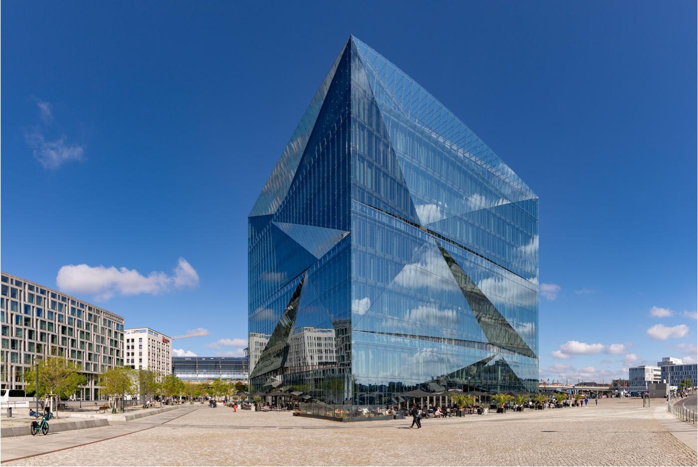
Not only is the architecturally striking facade shaping the cityscape, it is also part of the smart, self-learning system known as the “Brain.” According to CA Immo, the developer and project owner, the Brain interconnects all building systems based on real-time data from 3,750 sensors, 750 beacons and 140 mobile antennas. It collects information from the environment, as well as from occupancy, user behaviour, habits and preferences.
Based on this data, the system identifies, for example, patterns in peak load, temperature development and occupancy profile, and dynamically optimises ventilation and cooling systems. Maintenance requirements are also detected at an early stage: the Brain automatically triggers technical facility management interventions before malfunctions occur, significantly reducing the effort involved.
The facade makes a major contribution to the the cube’s energy efficiency. For this project, a special facade glass with a solar-absorbing PVB (polyvinyl butyral) layer was developed. In addition, an automated sun shading system between facade layers reduces heat gain in the interior. According to CA Immo, around 50 percent of the building’s primary energy demand is covered regeneratively through heat recovery and solar thermal systems.
The intelligent system also consolidates data from building automation, energy supply and user environment into a digital twin. This facilitates simulations, evaluations and adjustments during ongoing operation – and creates the basis for an adaptive, resource-efficient building management.
Certified with WiredScore Platinum and DGNB Platinum, the cube berlin represents an innovative building concept that embraces digitalisation as a structural principle. The real-time interconnection of all systems and the integration of AI make it a model for intelligent, self-learning office buildings where sustainability, efficiency and user comfort are optimally combined.
Case 03: Siemens
Technology as an enabler
With its flagship project in Berlin, Siemens demonstrates how modern technology can create new opportunities for the planning, construction and operation of a city district.
It is one of Europe’s largest urban development projects: On a former industrial site, more than a century old in Berlin-Spandau, Siemensstadt Square is set to take shape by 2035. Covering 76 hectares, it will provide a progressive living and working environment for around 35,000 people once completed. To achieve this, the global technology company Siemens is relying on numerous innovations – among them a digital twin that facilitates the multidimensional planning, building and operation of the district. Afzal Shabaz Mohammed, Vice President IT Technology and Innovation at Building X/Smart Infrastructure at Siemens, explains: “The digital twin already allows us to make better and more flexible decisions. That’s a major advantage, especially given the project’s long timeline and the many stakeholders involved, such as public administration, Siemens itself, its technology partners and the local community.”

Afzal Shabaz Mohammed
Vice President IT Technology and Innovation in Building X/Smart Infrastructure at Siemens
One example: During the planning phase, developers can use simulation tools to analyse how sunlight falls on the streets at different times of day and in varying weather conditions. This helps determine the optimal placement of streetlights and building lighting, which can then be integrated into the building design at an early stage. “Another goal is automated lighting adjustment. For this, we’ll use not only daylight sensors but also motion and presence detectors. Real-time lighting control based on traffic volume and weather conditions is also conceivable,” says Mohammed, adding one of the most important early lessons: “It’s like Lego bricks fitting together. By intelligently connecting the different layers of an urban district, we’re breaking down data silos that have traditionally been viewed isolated from one another.”
The technology-driven yet tailored approach Siemens is pursuing in Berlin is one Mohammed also recommends for other large-scale urban projects: “Copy-and-paste doesn’t work. You always have to assess what’s really needed and what makes sense – for instance, considering local climate conditions.” At the same time, he points to numerous projects worldwide that already show “how urban technologies can be effectively applied in areas such as buildings, mobility, energy, lighting or water management.”
For Mohammed, who has accompanied many major projects during his more than 20-year career at Siemens, one thing is clear: “Urban technologies are indispensable – they are the enablers of the city of the future. In sensor development, in particular, we’re seeing a great leap forward. Environmental sensors for measuring air quality outdoors, for example, are becoming ever more compact while delivering far more relevant data – the kind we need to help shape livable cities.”
Interview
“Technology helps our cities sense the needs of their inhabitants”
In an interview with SCIO, Professor Carlo Ratti, renowned Italian architect and founder of the Senseable City Lab at MIT (Massachusetts Institute of Technology) in Boston, explains how technology can be used to make cities more sustainable.
Mr Ratti, you have been working on the integration of technology into urban planning and urban life for more than 20 years. Can you give us a concrete example of how technology can act as an enabler for positive developments in a city?
Carlo Ratti
Founder of the Senseable City Lab, MIT
© Lars Kruger
For instance, we have been using technology to make urban forests more resilient – which is crucial, as such areas are essential for maintaining a city’s ability to function as a healthy ecosystem. At the Senseable City Lab, which I founded in 2004 at MIT in Boston, our “Diversitree” project leveraged open-source data from the platform OpenTrees.org on global tree inventories, analysing street trees in eight international cities, including Buenos Aires, Amsterdam, Paris and Melbourne. The data is collected with the help of satellite images, aerial photographs and crowdsourcing from citizens, among other things. We assessed their performance against diversity benchmarks and indices, examining variations within city centres and their outskirts. This analysis allows practitioners to more effectively target efforts to improve tree composition, ultimately making urban forests healthier and more resilient.
What do you mean by a Senseable City?
I have never been a fan of the term “smart city” which puts too much focus on the technology and not enough on the ways we use that technology. That’s why I picked the name Senseable City Lab – we like to use digital technologies to help our cities sense the needs of their inhabitants and respond intelligently. From my point of view, the projects that will change our cities for the better are those that respond and adapt dynamically to people and the environment. Imagine roads that change their layout based on traffic flow, or buildings that dynamically adjust their temperature and lighting in response to real-time feedback from occupants.
What are the advantages of the interdisciplinary approach you take in the Senseable City Lab?
Cities are among humanity’s most intricate creations, requiring diverse perspectives and expertise. At Senseable, we bring together researchers from architecture, design, urban planning, social sciences, various engineering fields, computer science and complexity science to tackle urban projects and, in this way, take account of the complexity of cities. This interdisciplinary approach is also central to our work at my innovation and design firm Carlo Ratti Associati (CRA) and is highlighted at the 19th International Architecture Exhibition of La Biennale di Venezia.
A focus of your work at MIT is the future of mobility. What can cities do to improve the efficiency of their transport infrastructure?
Before I provide an example – remember this: cities, which have thrived for 10,000 years, are fundamentally about bringing people together. Therefore, mobility is essential. By harnessing real-time data, promoting a variety of transportation options, encouraging shared mobility services and designing mixed-use neighbourhoods that cut down on long commutes, cities can better fulfil their primordial role. Technology can help here.
Can you give us an example of a particularly innovative project in this area?
A project we’re proud of is “HubCab”, which we started in 2013. We analysed over 170 million taxi trips in New York City to figure out how to make ride-sharing more effective. As we were able to show, this can be achieved through carpooling networks. If implemented well, ride-sharing can transform urban mobility and help cut down on congestion and pollution. Incidentally, the research results had a direct influence on the development of Uber’s “UberPool” function, which enables users to share journeys and thus save money while minimising delays.
If you had the choice, which city would you like to redesign?
I’m particularly interested in honouring the legacy of modernist city planning and architecture, while adapting it to meet contemporary environmental challenges. With CRA in 2020, we worked on the master plan of Brasília as part of the Biotic project. This new district, spanning 1 million square meters, is devoted to technology and innovation. One idea is to open up interior spaces more to the outside by using digital technologies to control sunlight, wind and temperature. Electronically controlled wooden facades can be opened and closed like curtains.
Professor Carlo Ratti is an internationally renowned Italian architect, engineer and urbanist, known for his innovative approaches to the integration of technology into urban planning and urban life. He is a professor at the MIT, where he directs the Senseable City Lab, an interdisciplinary research centre dedicated to the study and design of smart cities. Ratti is curator of the 19th International Architecture Exhibition of La Biennale di Venezia, which takes place in 2025.
Image sources: Bruno Coelho / Alamy Stock Photo
Disclaimer (Extract) – Copyright and IP Rights: The contents published on this website are subject to German copyright and ancillary copyright law. Any utilization not permitted by German copyright and ancillary copyright law requires the prior written permission by the provider or the respective owner. This applies in particular to the copying, working, translation, storage, processing and reproduction of contents in databases and other electronic media and systems. Third-party contents and rights are identified as such in this regard. The unauthorised duplication and forwarding of individual contents or complete pages is not permitted and may possibly be punishable as a criminal offence. Only the creation of copies and downloads for personal and private and non-commercial use is permitted. The use of this website as external link shall only be permitted upon prior written approval oft he provider. Each and any firm or trademark is sole property of the relevant company. Citations of trademarks and names of third parties have a purely informative character. You will find the complete disclaimer in the imprint.